Saturday, 11 May 2024

El Salvador - The Lighthouse of the Pacific

 May 10


Hello everyone!


May 10th is Dia De La Madre in El Salvador: Mother’s Day. It’s a national holiday here, meaning a day off work to spend time with those who are mothers. Or do something that your mother may not approve…


Before hiking Volcan de Izalco

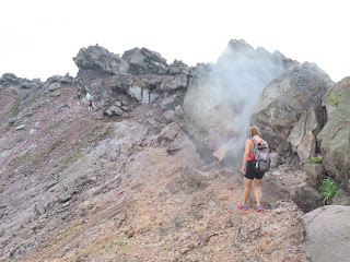
Just inside the edge of the crater of Izalco

That behind us is Volcan de Izalco. It is El Salvador’s youngest volcano. It is said to be one of the more difficult volcano hikes in the country. Having only scaled two volcanoes (Boqueron and Santa Ana) in Central America’s smallest country, I wasn’t really sure what that meant. Particularly in comparison to the beasts in countries to the north and south

Izalco is the cone-shaped volcano on the left 

A pretty view of Izalco framed by foliage from Cerro Verde

Not to say that there was a lack of respect for the Izalco volcano. When viewed from nearby Santa Ana and Cerro Verde volcanoes, it looks…steep.

Cerro Verde is on the left, Izalco on the right

From the starting point of the Izalco hike,
you're actually at a similar height to its peak

By some judges, it’s also the most active volcano in Central America. It’s erupted more than 50 times since 1770. On average, that’s once every five years. It erupted so much that it was given the nickname of ‘the Lighthouse of the Pacific’. This is because the ships were guided by the constant eruptions and lava flows from its top.

Apparently the steam is from previous rainwater
touching the rocks, rather than an imminent eruption

Pretty wildlife, such as this Spiny Liazrd, can be found in the area

It hasn’t erupted since 1966, however, and climbing to its peak is permitted. Knowing that the volcano was exposed to the elements, a group of us wanted to set off early to beat the sun. This involved meeting our guide at the petrol station for nearby Cerro Verde National Park, from where we would start our adventure.

The park has a coffee shop and overrated restaurant called Casa 1800

A slight misunderstanding meant that our guide was left stranded at the petrol station for the turning to head towards Cerro Verde National Park. Quite a long way from where we were when we realised this: in Cerro Verde National Park….

We had actually driven past that petrol station but
hadn't realized that this place, 30 minutes away from Cerro
Verde, was what he meant when he said 'Cerro Verde'

After managing to find a guide to take us before the public tour at 10:45am, we left at around 8:30am to head…down. Strange scenario this, one in which you have to hike down hundreds of metres from the Cerro Verde volcano before starting to scale Izalco. Very green, owing to the fact that it is dormant and hasn’t erupted in hundreds of years. 

Almost all of the first section was steps like these

There is a hotel higher up on Cerro Verde. Apparently it was built
so that visitors could stay and watch Izalco erupting. It
was finished soon after 1966: Izalco's last eruption... 

At its base, the volcano seems a bit more imposing. Our guide informed us that the streak down its centre which looks like a path is in fact incredibly dangerous, and that we had to zigzag along the side of this. 

Our guide said the word 'toboggan' when referring
to that streak. Not sure I'd strap in for that...

The start of the hike up to the top

In spite of the threats of a 45° incline, the walk up was reasonably easy to do, with lots of big rocks to ramble on. These rocks started to feel warm - and then hot - to the touch as we got closer to the top, which was a slightly surreal experience. The steam emanating from vents near the top and the lack of sunshine added to the atmosphere.

Its name in Nahuatl means 'place of the black sands'

Vegetation is understandably sparse on the volcano

A little over half an hour after starting from its base, we reached the peak of Izalco: 1950 metres above sea level. Unlike other volcanoes I’ve scaled, you can circumnavigate the top of Izalco. That means you have a 360 degree view: ranging from Cerro Verde and Santa Ana volcanoes to the north, to the…well, you should be able to see the sea. You can also see the lava field from the last eruption, in 1966.

The Pacific Ocean would be visible on a clear day

The 1966 eruption destroyed coffee fields but didn't,
to our guide's knowledge, result in mass loss of life 

Arguably the most fascinating view is the crater. A surprisingly shallow crater, which probably doesn’t descend further than 10 metres from the edge. Walking through the steam had the feel of being in a sauna. Whilst doing this, you can see how steep some of the sides of Izalco are. 

The crater is about 250 metres in diameter

Walking around the edge of the crater

The whole hike took a little under 4 hours at a pretty leisurely pace. It was nice to conquer a volcano which has a reputation of being a challenging climb. A very enjoyable Mother’s Day morning.

Going down was slow but not too slippery

Enjoying the views and a water break!

A more enjoyable volcano than other recent ones we have scaled

A 6km jaunt in total


Love you all,


Matt