February 17-18
Hello everyone!
Still without a car and not wanting to spend a lot of money, I pondered what to do during a week-long February vacation. Without flying, options were limited. With that in mind, I decided to go old school and book myself on a bus to Guatemala City for two nights.
 |
| In front of Palacio Nacional |
 |
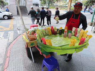
| My mango man near the main plaza |
 |
| One of many, many malls |
 |
| Oakland Mall is actually quite nice, with lots of greenery, bowling alleys and trampoline parks |
 |
| This was the 'economico' bus - my return bus, a 'diamante', was purple and really comfortable |
 |
| The Chinamas border crossing |
 |
| Most visitors won't see the Torre del Reformador, a Guate version of the Eiffel Tower which straddles a major road |
 |
| This dual carriageway, Avenida Las Americas, is only 200 metres or so from the airport |
 |
| Plaza España |
 |
| This image, created by another blogger, suggests which zones are safe (green), not safe (orange) and downright dangerous (red) |
 |
| Bumper to bumper |
 |
| Yep, I made it up to 46,000 steps on that day |
My first stop, an approximately 3 km walk from the hostel, was the bohemian area of Zone 4. This is one of Guate’s up-and-coming neighbourhoods, described as its equivalent to Brooklyn in New York City. It has a lot of graffiti and a large number of coffee shops.
 |
| Being quite early in the morning, most places were closed |
 |
| A mural of indigenous people |
 |
| There are some government buildings on this street |
 |
| This was the residence of Mariano Beltranena y Llanos, who signed the Act of Independence |
 |
| I think this building was opened in 1959 |
 |
| This is a sort of protest - it is missing a leg |
 |
| Lots of colourful handicrafts |
 |
| Sweets in the basement |
Further north (a little over 2 km, if you’re counting) is one of the city’s quirkier sights: a relief map of the country. This map of Guatemala’s physical topography has recently been refurbished, and shows the country’s numerous volcanoes, lakes and coastlines.
 |
| View from one of the towers beside the map |
 |
| View from 'sea level' - this is the Pacific side |
 |
| The brown splodges are the settlements of Guatemala City and Antigua |
 |
| The perimeter of the surrounding wall is 215 metres |
 |
| It roughly translates to 'Book of the Community' |
 |
| The text was probably written around 1550 |
 |
| Jaguars are commonly seen in Maya art due to their connection with power and the underworld |
 |
| The delightfully-named 'Grotesque Head' has indigenous writing on the skull |
 |
| Iglesia Yurrita, a pretty Gothic church |
 |
| Greek lomito pizza at Del Griego - sublime |


No comments:
Post a Comment