Sunday 30 April 2023

El Salvador - A Game You Want to Lose

April 13


Hello everyone!


It’s funny how traffic can cause you to find treasures that would otherwise get missed. In order to avoid sitting in a traffic jam when returning south from Suchitoto, we found that our new route would be passing this…

The pyramid at Cihuatán

Ruins of a lost city from over 1000 years ago

On top of the pyramid

This is Cihuatán, an archaeological site near the town of Aguilares. On its website, the Ministry of Culture describes Cihuatán as ‘one of the most important archaeological sites in Central America.’ When you consider that the region includes places such as Chichen Itza, Tikal and Copan, which are internationally renowned, it is a bold statement.


It is about 24 kilometres west of Suchitoto


Cihuatan translates from the indigenous language as ‘place of the woman’, based on the idea that the nearby volcano looks like a sleeping woman.


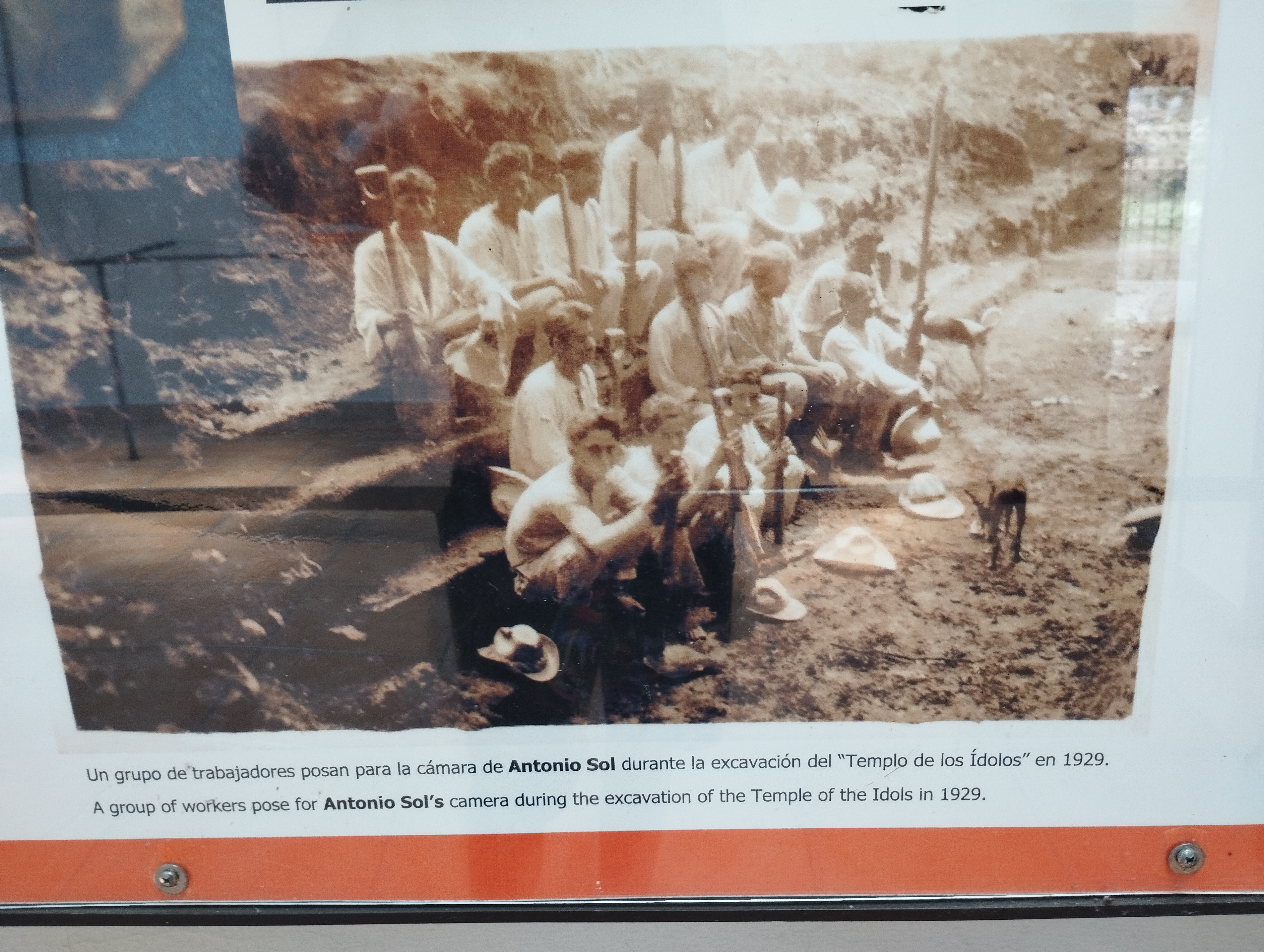
The park is a large complex of pre-Columbian ruins which were believed to be constructed between the tenth and twelfth centuries. Many of the remains were discovered in one of El Salvador’s first official digs, by a man called Antonio Sol in 1929. 


A photo of excavators during the 1929 dig

This photo shows how well some sites were hidden


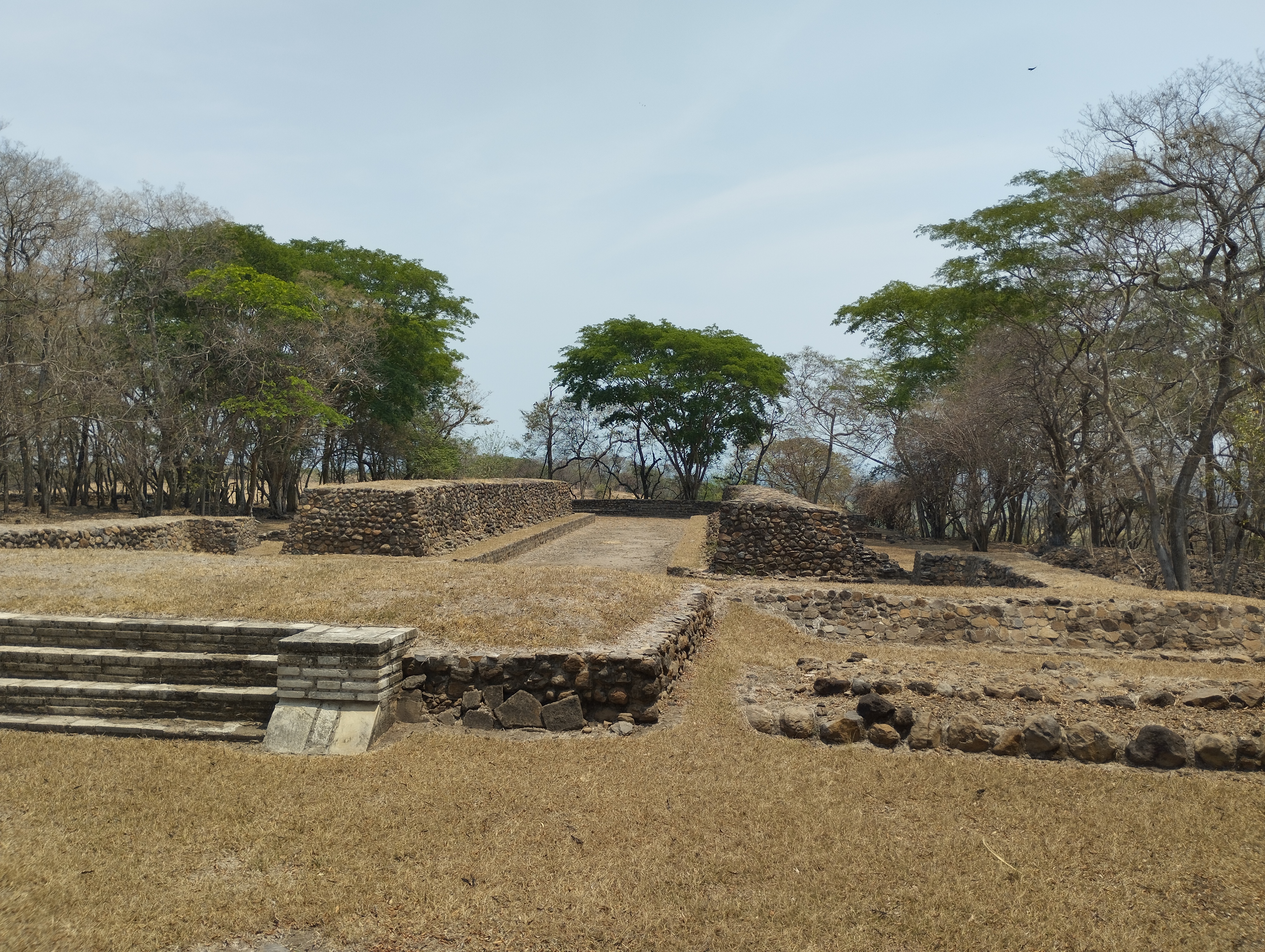
Cihuatán is thought to have been the capital of a region now depicted on maps as the western part of El Salvador. Evidence of this includes a variety of temples and a royal palace. The fact that the latter was covered by a forest at the time of its discovery less than 100 years ago suggests that there may be other memories hiding in plain sight.


The excavation site is about three square kilometres and the park is over three hundred hectares in size

It is the largest archaeological site in El Salvador but is smaller than many others in the Mesoamerica region


The main pyramid is the setting of this palace, upon which the leaders of the tribe would sit and observe. The design allows sound to travel up - we could hear our guide talk to us from the bottom without him raising his voice.


I can't find proof but I think our guide said it was thirteen metres tall

It was also pretty warm when we visited so I hope they had some Sun protection!


Who these rulers were is still a discussion rather than set in stone. What I’ve read is that many of the artefacts found by ceremonial structures suggest ties to the east and north, especially with peoples from Veracruz in Mexico, whilst other artefacts show trade with the Maya peoples of Guatemala and with people to the south in Nicaragua. What is known is that it was a large settlement which had prestige.


The structure had Mayan clues such as those dots

It is very much dry season at the moment -
I imagine it looks a lot greener later in the year

Other elements that have been discovered are two ‘ball courts’. These are seen as a common thread of Mesoamerican identity. It seemed like a game similar to volleyball would be played down a long, narrow alley, with supporters stationed above. The game is known by a variety of names, from 'pelota Maya' to 'pok-a-tok'. The main thing we learnt was that the winners…got sacrificed. Play for a draw?


They also found a 'sauna' room connected to the court

Apparently the game is the oldest known team game, dating back to 1400 BCE 

Another entertainment venue unearthed here is what is known as a ‘dance platform’. The one here has been damaged by the Salvadoran Civil War, when it was used as a platform…for machine guns. It is lucky that much of this site was undamaged by the thirteen-year conflict.


Not sure where the DJ would be based...

Ancient fortifications were easily adapted for modern fighting


The settlement and people that lived here are believed to have been destroyed by a large fire started by invaders in around 1150 CE. Who instigated that fire is not known. Finding obsidian, a material known to be used for lances and arrows, offers historians possible clues.


This may have been a temple

The darkness of the rock, not found in the region, suggests fire


There are five archaeological parks in El Salvador, and hundreds of small sites. It was a pleasant surprise to stumble upon Cihuatán and to learn a little bit about life in the area before the European arrival. In case you’re wondering…traffic was fine!


The trees here were fascinating!

Not worth sacrificing, I think... :-)

Love you all,


Matt

Tuesday 18 April 2023

El Salvador - Sweltering in Suchitoto

April 11-13
 

Hello everyone!


After 48 hours of recharging, washing and collecting visitors, we were back on the road. This time we were staying within the frontiers of El Salvador, heading north to one of the country’s highly recommended places to visit: Suchitoto.


Mini and Maxi joined us on this adventure

Suchitoto in the indigenous Nahuatl language
means 'place of birds and flowers'


The city is, with traffic, about a two hour journey north from Santa Tecla. Northern El Salvador was the hiding spot for many rebel villages during country’s civil war between 1980 and 1992, with soldiers often hiding in tatủs, cave hideouts scattered in the rugged terrain. Suchitoto was a key rebel village and battle town during this time. Next time I come up north, I’ll spend more time learning about the civil war and its impact here.


The closest I came to death in
Suchitoto was seeing this sign

The Civil War ended a little over 30 years ago

Suchitoto’s history runs deeper than the civil war. It is often cited as El Salvador’s ‘colonial town’, its equivalent of Antigua in Guatemala. There are similarities, such as the cobbled streets, colourful houses and sweet balconies. It is a lot smaller.


The village dates back to pre-Columbian times

The town was also very briefly the capital of El Salvador

One of many aesthetically pleasing houses

Its most beautiful building is actually more modern. The Santa Lucia Church was built in 1853. With its white-washed façade and surrounding bougainvillea, it is a very attractive site on one side of the main square.

Before this structure, Suchitoto's church was made of
...straw...you can imagine what happened to it!

It was declared a National Monument in 1978

The inside of the church

I spent a lot of my time…in a hammock. Suchitoto is a drop in altitude from Santa Tecla and in a bit of a basin, resulting in it being rather warm. It reached 99℉ on one of the two afternoons we spent there.

Turns out Maxi likes hammocks as well!

Riding on a local bus would have been very hot

Water breaks were key for the dogs

Water is a great way of cooling off in sweltering heat. Unfortunately, we are in the middle of the region’s ‘dry season’. It has briefly rained once since mid-October. This explains why Suchitoto’s nearby waterfall, Los Tercios, looks like this…

The top of the waterfall - its height is about 13 metres

The waterfall is formed by overlapping
hexagonal blocks of stone

Still, being able to see the hexagonal rock structures is pretty impressive. A young French couple were even climbing the thing when we got there!


A very different place with water, I imagine

The man said the rocks were
too slippery to get to the top

We could see water from our quaint B+B, however. We had a stunning view of Lake Suchitlán, a man-made lake. This was formed in the mid-1970s as a result of the construction of the Cerron Grande Hydroelectric Dam. 


The dam provides a lot of El Salvador's electricity

The water level can rise up to 15 metres during rainy season

Mini pondering the creation of energy from water...

The lake is large, stretching dozens of kilometres across. We took an early evening boat ride to check out the sunset from the water. In doing so, we learnt that the lake has some interesting stories.

There are many little islands in the lake

Sunset from the lake

There are a few small villages on the other side of the lake -
this ferry, including 4x4 vehicle, transports people from place to place


One of these was explained to us after we noticed three small white crosses bobbing in the middle of the water. This was the site of a plane crash in 2014, when a Salvadoran military plane landed in the middle of the water. The crash killed three of the four people on board. Strangely, they decided to leave the wreckage of the plane on top of a nearby rock once salvaging it. I guess it's a sobering reminder of one of the lake’s sadder stories.


The three crosses aren't visible in this picture

The plane is on the top of that rock


Suchitoto is a very interesting place. There’s a lot more to explore for us in the future. Probably at a time when it’s not 99℉…


Love you all,


Matt

Sunday 16 April 2023

Guatemala - Holy (Semana) Santa!

April 5-8


Hello everyone!


Sunday, April 9th is Easter. It is the reason I have two weeks off from work. It is also a very big deal in Central America. A very big deal.


Purple is the colour for Lent

A parade float depicting Jesus being moved into the cave

There aren’t many places that make as big a deal out of Holy Week - called Semana Santa - in the region as Antigua. That’s the city in Guatemala, not the country. 


The city's full name is Antigua Guatemala

The red dot is Guatemala City, the capital


Quick admission at this point: when Hannah and I decided to come to Antigua, we didn’t realise that we were trying to come at its busiest time. And boy is it busy in Semana Santa. 


The tradition of the carpets dates from conquistador times

The grounds of the Merced church were
packed throughout our time in Antigua

Why Antigua in particular? I’m not entirely sure. It certainly is a place steeped in colonial history, where the Spanish developed a settlement said to be their most important between Mexico City to the far north and Lima to the far south. The city, whose full name translates as ‘Old Guatemala’, was the capital of the Captaincy General of Guatemala for 230 years after its founding in 1543. It suffered a horrendous earthquake in 1773, which resulted in the capital being moved to a new 'Guatemala City'.

The ruins of the Candelaria church date from 1548 

This cool structure was part of the city's laundry basket 

Antigua’s most iconic man made landmark is the Santa Catalina Arch. It was built in 1694 and originally connected a convent on one side of the road with a school on the other side. The nuns, who had to avoid all contact with the outside world, used a hidden passageway in the arch to cross between the two institutions.


The arch somehow survived the 1773 earthquake,
which decimated most of the city 

The clock was added in the 1800s and
needs to be wound every three days

There are many other colonial relics found along the cute, cobbled streets. Many are found around the Central Plaza (Parque Central), including the city’s massive cathedral and Palacio de los Capitanes.

From here, the governor ruled an area stretching
from modern-day Mexico to Costa Rica

The cathedral is built on the rubble of the
original, which was destroyed in the 1773 earthquake


I said man made landmarks for a reason. Visible from Antigua are three towering volcanoes: Volcan de Agua, Acatenango and Volcan de Fuego. The latter is constantly bubbling and spitting at a low level. You can hike overnight up Acatenango, which allows you great views of the Fuego and an incredible sunrise. This also involves advance booking…


Volcanoes are a key part of Guatemalan culture

Volcan de Agua is most visible from the city -
Acatenango and Fuego are to the west (to the right of this picture)

…meaning we hiked up part of a different volcano, called Pacaya. Though not as frequent or violent as Fuego, Pacaya has erupted as recently as 2021, as well as in 2010 and 2014. 

It rises to 2,552 metres above sea level

You don't climb to the top of the volcano -
this was pretty much as high as we went 

It took us a while to get to Pacaya, mainly because the roads were blocked for Semana Santa activities. You’ll see why later, but this resulted in having to backtrack multiple times and taking two-and-a-half hours to travel a journey which normally takes less than an hour.

It's a popular hike, probably because it can be completed quite quickly

Solidified lava from recent eruptions

The hike was gentle, particularly when compared to other volcano hikes which can be done here. Still, some opted for four-legged help…

In front of Pacaya's peak

There was a baby screaming his eyes out on one of these -
be thankful I didn't take a video of that to use on here

We didn’t go near the top, instead settling in a basin which had solidified lava from recent eruptions. The rock is warm to the point that the guides pull out their party trick: roasting marshmallows. It was a pleasant hike and a world away from the chaos of the town.

There isn't a fire over which to cook them...

...meaning they get put in the lava, and they get bits of
molten rock on them. Crunchy and underwhelming.

This was Good Friday. It seemed to be a good Friday to watch a parade. There were many of them. These actually happened consistently throughout our time in Antigua. Each different parade depicts a different aspect of the events of Holy Week, with Friday’s main parade of over 25 floats depicting the death and burial of Jesus.

It's suggested that up to a million people
visited Antigua during Holy Week before Covid

Whilst Wednesday and Thursday were purple,
Friday had more black being worn


It’s a bedazzling, strange experience. There’s an aura as the floats wobble up the street, being carried by people of any age or gender in traditional Christian clothing. The accompanying music is tuba-heavy, loud and sombre in its mood. Understandably given what they are depicting, the atmosphere is stuffy; not just because of the clouds of smoke from the incense being hurled around.


Floats ranged in size from small, like this
one above, to dozens of metres long

Incense adding to the atmosphere outside the cathedral


Yet then you notice one of the parade with a selfie stick. Or you see a parade being accidentally blocked because a woman has decided to try to sell socks in the middle of the road. Or the parade winds down a different road and you’re left with the usual tourist hawkers trying to sell water or hats which are precariously balanced high on their head.


Socks > important religious procession

More likely pollution, but maybe this incense-waving
explains the haziness of Antigua's air!

I've tried to count more than once. Failed every time.


One of the main elements of Semana Santa is the creation of colourful carpets, called alfombras, which are painstakingly designed, measured and created in the middle of the street. They're amazing to see but are soon deconstructed after finishing - I'm not sure why.


Incredibly beautiful but they disappear so quickly!

Lots of pretty patterns and colours on the cobbled streets

An alfombra was why our drive to Pacaya got diverted. Having seen the care taken to create these stunning designs, I’m happy our bus didn’t bulldoze its way over it!


The alfombras are made from sawdust and wood
chippings - they could be bought in the main market

We're not sure whether you can just rock up to do these or
whether you need council permission and get given a
particular place in which to build your carpet


Antigua is relatively close to us and easy enough to reach, even for a weekend. We’ll definitely be back, though probably at a quieter time! Even so, being in the city for part of Semana Santa was at times a powerful experience which demonstrated the power and reverence of religion in Central America.


Happy Holy Week

Spending time with friends in a tiny, adorable restaurant called Por Que No, which translates as 'Why Not?'


Gracias Antigua - we'll be back

Love you all,


Matt