Sunday 7 January 2024

El Salvador - Revolution in the Air

January 5-6


Hello everyone!


2024 is a big year for global politics. Apparently over 70 countries will hold national elections this year. El Salvador is one of them, with the elections happening about one month from now. The expectation is that they will be peaceful, free and fair. It wasn’t always like this here…


A propaganda poster in the Museo de la Revolución

Maxi and Mini trying to keep warm near Perquín 

I have written a little bit about El Salvador’s civil war before. Essentially, it was a battle between two sides: the ruling government/military dictatorship (delete as how you feel appropriate), and the guerrilla resistance/communist rebels (delete as how you feel appropriate). The latter were known as Farabundo Martí National Liberation Front, which was shortened to FMLN.

Artwork depicting FMLN fighers

People of any age and gender fought for the FMLN cause

The Civil War started in 1979, when a military coup overthrew the president and protesters were killed. It ended with peace accords signed in Mexico in 1992. At least 75,000 people were killed in that time, with many more ‘disappearing’. The war lasted such a long time in part because of successful FMLN resistance. This resistance mainly focused on, and was successful in, two of El Salvador’s departments (what we would call states or counties): Chalatenango and Morazán. On this excursion, I visited the latter.

This screenshot shows the international flavour of the
civil war, which occurred in the Cold War

Morazán is in the northeast of El Salvador, sharing a border with Honduras

I hadn’t actually meant to come here - as you’ll see on the map, it’s a relatively long way from Santa Tecla. I had been looking for a pet-friendly camping spot in the country so I could go away with the dogs before work resumes on Monday. I found an interesting camping spot, sent a few messages, then decided to book. Only then did I look at a map and realise I’d committed to an almost five-hour drive in each direction.

The dogs slept most of the way, aside from growling
at a petrol attendant who wound them up

My camping spot was called
Pájaro y Nube - it was pretty basic

Nonetheless, I’ve been wanting to come up to this area for a while to learn more about the war. Specifically, I wanted to visit the settlement of Perquín, which houses the Museo de la Revolución.

This headline says 'Perquín: the place that never dies'

The building is fairly inconspicuous


It doesn’t look like much from the outside but it is an interesting place which showcases a different perspective of the conflict: that of the resistance. The rooms inside the building focus on the key people involved for FMLN, evidence of solidarity with their struggle…and weapons. Lots of weapons.


Memorabilia includes badges and gadgets used by FMLN fighers

Solidarity posters (many of which were in German)
often decried US influence in the conflict

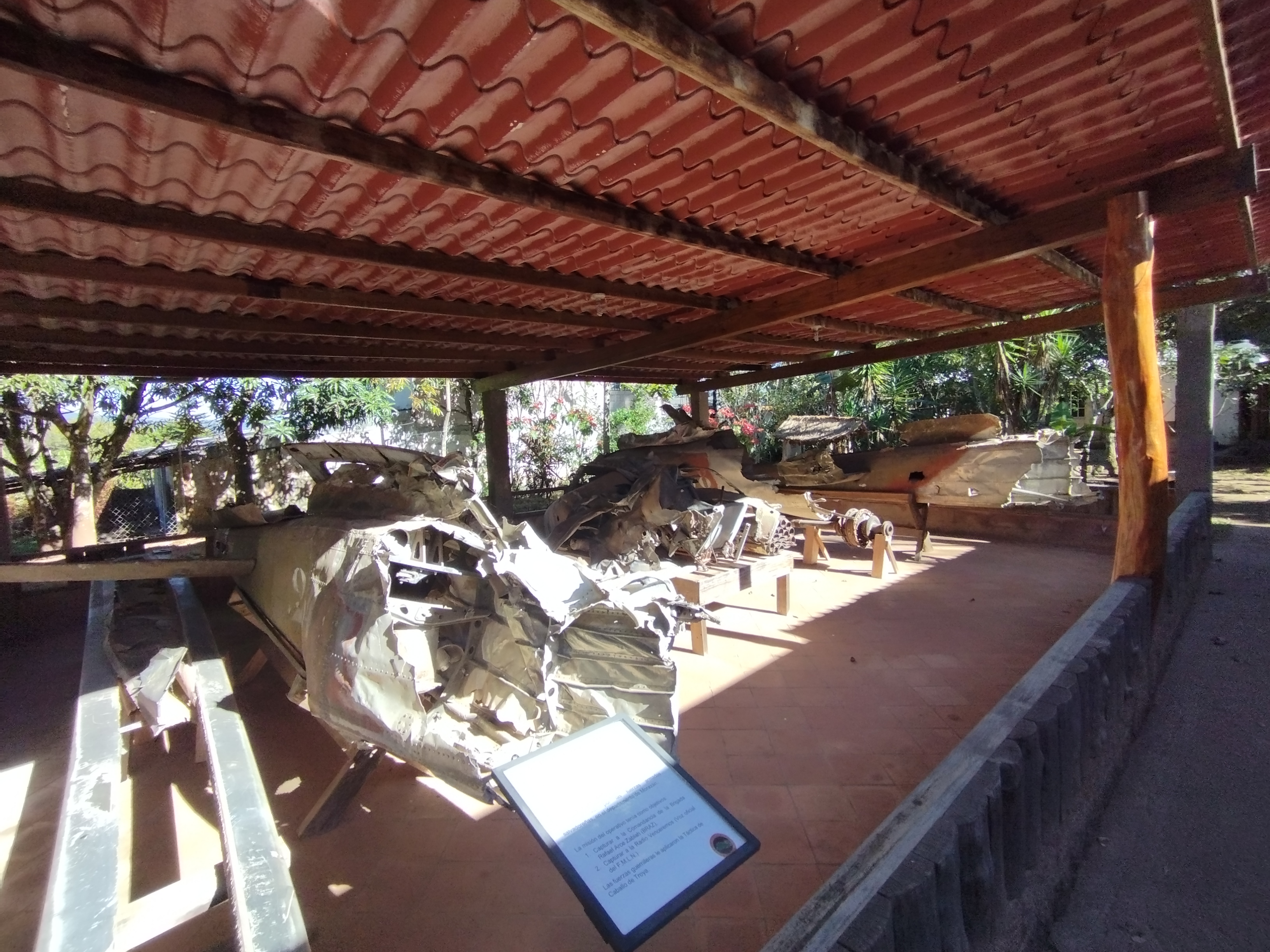
Outside the building are ‘souvenirs’ of a sort. The shattered, rusted chassis of a plane which the FMLN managed to shoot down over their territory is proudly displayed outside. One of the people on board was apparently the man who enacted the El Mozote massacre which I talk about later.

These probably killed innocent people

The craft was shot down in October 1984 - all on board died

The next section of the museum is where things get a bit more interactive and quirky. One of the main methods of communication was radio. The FMLN’s main mouthpiece was called Radio Venceremos, which roughly translates as ‘we beat’ or ‘we overcome’. A small room has a mock-up of their radio station, which was hidden elsewhere in a cave. What is cool is that many of the places in the museum which I’ll refer to shortly had different radio broadcasts from Radio Venceremos being played as background noise.

It was still transmitting in 1992

I think the radio station was in a cave a few kilometres south of El Mozote 

From here you can buy a ticket for the next section. We pass through a beaded curtain (well you don’t have to, there’s no wall either side). The ‘beads’ are bullet casings. This takes you into a slightly more jungly area with three main elements.

The gateway with the bullet curtain

An insight into what the terrain was like

One is more of what you’ve already seen inside: guns. Lots of guns. Apparently you can pay a small fee to pose with them in FMLN uniform. I didn’t feel the need to do that. 

Rockets fired in the area

A variety of machine guns and rifles on display


I did feel the need to go into the tunnels which were dug as secret passages and hiding places during the war. Having seen the bomb crater nearby, I’m not sure how effective these actually were, though they must have had some benefit.


Squeeze to get in!

The tunnel was an L shape, with the total length probably being around 10 metres

Finally, there are some bridges to cross. The museum is thus a mix of sobering memorabilia and a mini adventure playground. I wonder whether that’s the vibe the FMLN would have wanted to share.

I didn't go on this bridge...

This was swaying with every step!

It’s fair to say that the FMLN and its occupied areas weren’t treated particularly favourably by the military government. Nowhere is this more evident than in a village about 10 km southeast of Perquín, a place named El Mozote. Throughout 1981, government forces had been conducting ‘sweeps’ throughout northern provinces, indiscriminately killing anyone they found. They arrived in El Mozote in December 1981.

It felt like quite a big height drop from Perquín to El Mozote

The eerie main square

What happened next, on December 11, has since been described as the largest massacre in the Americas in modern times. Over 800 men, women and children, almost entirely civilians, were executed. Initially, both the national US governments claimed this was bogus or had been staged by FMLN. They later came to accept the reality and horror of what had happened, with an official apology being offered by El Salvador’s government in 2011. The memorial which is part of the small main square in El Mozote, simply listing names and ages of the victims, is simple yet powerful.

The memorial - the names are on the wall at the back

Many names have an age of zero - I'm not sure whether
that's because they don't know the age, or whether
the government forces killed scores of babies

Near to the village is a peace monument, towering at least 15 metres tall. It has four statues of notable peacemakers and inspirational figures from the 20th Century: Martin Luther King, Pope John Paul II, Mother Teresa and Mahatma Gandhi. Ironically, the Monument to the Reconciliation in San Salvador was torn down this very week by the current government.

Google Maps says this is 'permanently closed' - it isn't!

MLK

A January newspaper documenting the removal
of that strange peace statue in San Salvador 


The country is trying to develop the area (it has created the ‘Ruta de la Paz’ to try to connect the important places) so that more people can come and appreciate both the history and the natural beauty which survived twelve brutal years of civil war. One consequence of this is that the roads are either in questionable condition or are being improved, meaning that driving here isn’t as smooth as other parts of the country.


Roads are often narrow, particularly in
villages, which can cause gridlock

The road near my campsite was being reconstructed

As for the dogs? Mini and Maxi were less interested in the history of Morazán but enjoyed walking up hills to some spectacular viewpoints. The ones I could find, anyway. Improving signage to make it clear where places like Mi Pedacito de Cielo and Cascada Caracol are would be useful. Lots of pine forest, fresh air and gushing waterfalls made this a worthwhile whirlwind trip.

Maxi enjoying a walk up Cerro de Perquín

Mini doing her favourite thing, being dragged across
the grass near the top of Cerro de Perquín

Salto El Perol, a collection of pools and a waterfall

The water was pretty cold!

El Salvador, like many places in Latin America, had a civil war and has had many problems since its conclusion. Remembering the past to avoid repeating its mistakes is a vital lesson for history, and one which the Morazán department can help people here to do.

The Rio Lempa

Going underground!


Love you all,


Matt

Friday 5 January 2024

El Salvador - The Pompeii of the Americas

January 4


Hello everyone!


You’ve probably heard of Pompeii. There’s a song called it. More famously, there was once a thriving town southeast of Naples in Italy. I say ‘was’ because in 79 CE, the nearby volcano of Vesuvius erupted, with the ash covering the town in such a way that it ‘froze’ it in time until it was found centuries later. Turns out there’s an equivalent on my current doorstep…


A Mayan communal building, which has been excavated from ash at Joya de Cerén

Many fragments of crockery have been found,
though many pieces are fully intact

What you see above is part of a complex called Joya de Cerén, an archaeological site which has UNESCO Heritage status. It’s actually El Salvador’s only site which has this prestigious award, given to it in 1993. Interestingly, this is four years before Pompeii and nearby Herculaneum were assigned this status, which helps to protect them.

Neighbours Guatemala and Honduras have 4 and 2 UNESCO sites respectively

A human footprint. This is about 1400 years old!

The reason this place is described as ‘Pompeii of the Americas’ is pretty simple: the same thing happened here. The town of Joya de Cerén was a pre-Hispanic farming community, consisting of many structures. It had been built on top of ash thrown from the eruption of a different volcano at Ilopango. That must have been enormous - over 30 km in a straight line! At least they didn’t have to deal with modern Salvadoran traffic…

A map detailing finds in the broader area

Ilopango is the lake on the right of this map

The community was established, with rooms which I will detail later, and all seemed well…until a much closer volcano burst. The Laguna Caldera erupted between 600 and 650 CE. Joya de Cerén was blanketed with ash. That ash was between three and five metres thick. Picture that for a second. It could well be taller than the room you’re in right now. 

The tree-covered area at the top of the picture is the Lagiuna Caldera

A lot of ash!

The upshot of this is that the town was completely covered, seemingly disappearing overnight. Apparently, an earthquake gave residents time to escape, which is why there are no human remains here. Another eruption a few centuries later, this time from the San Salvador volcano known as Boqueron, further buried the town.

Geologists have found that there are layers
showing five different eruptions affecting this area

It made me wonder how in the world this settlement was re-found. It happened in 1976, apparently when a tractor was digging to create a grain silo. When digging part of a hill, it came across something strange. That something strange was part of a house. The silo was put elsewhere and archaeologists got to work.

The front building here is a sauna!


Well, for about three years. Then the country collapsed into civil war, and other things were deemed to be priorities. It’s remarkable that the site wasn’t damaged in the ensuing fighting. Excavations resumed in 1989, and are still happening to this day.


The sticks are preserved parts of the building technique used at the time

A section which will be unearthed in the future

So what exactly did they find? You find out as you walk around different zones, the path weaving between them so you can see the excavations. These are protected by a high, curved, metal roof. Not quite sure how well protected they are when it rains sideways during the wet season, but I’d assume they know what they’re doing. Mostly, the walk takes you past elements of buildings which you would expect to see in a community: houses, food storage, the main community building in which it is believed decisions were taken.

The community building has clay benches,
which would be seats for authority

The middle building was a storehouse, where they would keep food.
Husks of corn have been excavated, having been preserved for over 1000 years.

Oh, I almost forgot the sauna! Silly me. Of course there was a ‘sauna’ - called temazcal in the Nahuatl language, and ‘sweat bath’ on one of the signs - in such a hot climate. It was a dome with a small vent in the top for the steam to escape. They have excavated the bottom of the original (I assume it must have collapsed) and made a replica outside.

This picture hopefully gives an indication of the size of the area

"Just going to the sweat house, back later!"

The inside of the dome is small but could probably comfortably fit several people. The replica shows the box of stones in which heat (fire) was ignited, with herbs being used to generate steam. A method of purification, much like modern-day saunas. 

This structure is a little under 2 metres tall

The inside of the sauna


For me, the smaller elements found in or next to these larger structures are what make this a remarkable find. Below, for example, is the skeleton of a duck. They know from subsequent research that this duck was tied to a post next to one of the houses. 


The duck skeleton - we now know that
duck was eaten by the local population

Many of the plates have what is seen as traditional Mayan art

Many of these items are housed in the museum within the complex. They show how well-preserved items found here were by that ash bomb. From pots and plates of various sizes to necklaces of shells and jade, all discoveries help us learn and understand more about this community and the broader pre-Hispanic civilisations.

This pot was about a metre in height

The museum also had plants and foodstuffs which were
carbonised, and were therefore preserved, by the ash

The necklaces are connected to the ‘House of the Shaman’, highlighting an aspect of the community’s beliefs. The suggestion from the findings here is that the shaman was actually a woman. In a nearby ceremonial centre, festivals connected to corn and fertility would have taken place. Possibly not at the same time. 

This here is a regular house


House of the Shamana - you can see a pattern on one of the walls

El Salvador has a few Mayan historical sites (I went to one at Cihuatan last April). Joya de Cerén is unique for how it has been preserved within the Earth for so long. If it wasn’t for deciding to build a grain silo, we’d have never found it and learnt much about pre-Hispanic life within the land of El Salvador. It begs the question as to whether there are any other ‘Pompeii of the Americas’ under our feet…

History is awesome


Love you all,


Matt