Wednesday, 4 October 2023

El Salvador - Conquering Peñón de Comasagua

October 1


Hello everyone!


I ran a race today near a village called Comasagua. I should have run it 12 months ago. It’s a pretty place which has a big rock on a hill. 


Big rock

View from atop the big rock


I’ve been here before, actually. In order to share the full story, we need to travel back in time. Strap in!


Whoosh!


Welcome to March 2023. On a warm Wednesday after school, a group of us decided to head west from town along some windy, undulating roads to reach the village of Comasagua. Though only about 20 km to the west of us, it took almost an hour to reach due to traffic in Santa Tecla. 


Closer to Comasagua, traffic disappeared. Thankfully.

The town is down a slope from this point

We were going to hike Peñón de Comasagua. Essentially, this is a large rock with a cross on top. Reaching the summit has been made easier by adding steps to the side of the rock.

View to the west

Hiking up to the top with snacks and drinks

I don’t know why there is a cross on the top. What I do know is that the views are mind-blowing.  

The colours were incredible

Watching a wonderful Wednesday disappear

I'm not laughing at God!


Alas, it isn’t always this serene and picturesque. Let’s go back a bit further…


Whoooooooosh!


It’s now September 2022. I’ve been in El Salvador for a little over a month and am keen to get running. A friend and I signed up for a run in an unknown place called Comasagua, which looks quite close to Santa Tecla.


Comasagua's main street: small


That run gets cancelled a week before. Here’s why…


Comasagua suffered significant damage during two heavy rains in September and October 2022. The former, which resulted in the army coming to help with the clean-up, led to the postponement of the race by a week. We already had plans the following weekend, resulting in the company offering to defer our entries to the 2023 race.


I was at Lake Coatepeque that weekend

Back to the present…


Another whoosh!


September has just turned into October. I’d love to say that means autumn is here but that’s not really how it works when your country sits inside the tropics. A 45 minute drive (mercifully traffic-free as it’s Sunday and before 7am) took me to Comasagua.


About 325 people did the 12km run 

I say traffic-free. Though there weren’t as many people as in other trail races I’ve done since arriving in El Salvador, there were enough people to swarm a little village nestled in the valley of multiple hills. This made parking tricky, and resulted in me having to park a kilometre out of the centre, across the road from a cemetery. A man in army uniform with a large gun said I could park there, which was nice.

How the buses navigate these streets, I have no idea

Having registered over a year before, I wasn’t sure of what distance I was doing until the day before. Nursing a dead leg from football, I was glad to discover that I hadn’t been ambitious/arrogant/idiotic (delete as appropriate) enough to sign up for anything longer than the shortest available distance: 12 km. Which, of course, was actually a little over 13 km. They did at least say this on the website!


It was only when I collected my bib that I knew I was doing 12km,
they hadn't responded to my questions before that time!

12...but really 13.2

My run started at 7:30am. The positive of this was actually having a lie-in compared to my regular working start. The negative was that the Sun was already feeling quite strong. Still, away we trot, heading towards that enormous rock in the distance.

Pupusas for sale near the start. Quite a few runners
were eating them 15 minutes before leaving...


Unlike the previous trail run in Ataco, this one started by going downhill. Quite steeply, and for quite a long time. This led to the implementation of what I feel is a national tactic when running of ‘sprint-as-fast-as-you-can-downhill-and-then-walk-uphill’. 


My Strava tells me that we dropped 150 metres in less than 4 km

This pink-flowered tree was a pretty sight

After a couple of kilometres, a right turn and dirt road take you up to the entrance of the ‘park’. For a second I was transported back to Malawi, running through fields of maize. An incline, at which everyone around me started walking, which possessed lovely views.

This maize had been harvested - taller grass came closer to the rock

The Pacific Ocean was part of the view on the way up

Once through the corn, you see the Peñón in all its glory. It looks particularly stark and resplendent with a blue sky behind it. Quite tall as well.

Running towards the rock

It's hard to see but there is a man
up there shouting down at us

I knew that the run incorporated the peak of this rock. I wasn’t sure how it would work with people running up and down what I remembered to be a narrow set of stairs. The railing was useful!

The man running down, in leopard print
kit, is a regular sight in these official races

After reaching the peak and getting checked off by a race official, it was time to take in the feeling of being on top of the world. The endless Pacific Ocean to the south. The miles of greenery and forest in the other three directions. Not a breath of wind. Hardly a sound, save for one man egging his friend at the bottom on from the top.

If you travelled due south from this point, the next land
you would hit would be the Galapagos Islands!

Taking a breather to enjoy the view


After coming down the rock, I was expecting to be heading uphill to return to the village. The fact that we veered left and continued downhill for a while made me realise that the last few kilometres may be quite steep…


Proper camera folk were positioned on the way back

In reality, it wasn’t particularly steep or slippery, with only one section threatening to put me on my rear end. The paths were fairly narrow and I understood why the race had had to be postponed briefly in 2022 - slipping down the sides of some of these hills would be fatal.

At 8km, we were 801m above sea level. At 10km we were at 963m...

Trails: narrow


A slow return up towards the village, a couple of final steeper hills, one minute lost when I couldn’t work out that I had to go around barbed wire…and done. Comasagua: conquered.


I imagine this wouldn't have been passable in September 2022

Medal with a time of 1:36:17

A year in the making, but an enjoyable run through the small village of Comasagua. Stunning at sunset, and rewarding if running before.

A lovely spot relatively close to the city

Peñón: completed it


Love you all,


Matt

Wednesday, 20 September 2023

El Salvador - Gimme some skin!

September 13


Hello everyone!


I’m quite lucky that my job allows me to visit and appreciate some pretty interesting places. A school trip this week gave me a better insight into life for people in El Salvador before the time of the Spanish conquest.


Being the model professional on a school trip...

That art piece actually has some quite graphic elements in the top row

We were taking our students to MUNA - the Museo Nacional de Antropología - as part of our dive into ancient civilisations. The museum, also called the Dr David J. Guzman Museum, is a small two-story building in the middle of the city which packs in a lot of artefacts and information within its walls.

Mayan art pieces found in El Salvador

Volcanoes have long been an
important part of the region's history

Traffic means that the 6 kilometre trip can take quite a long time (it took us 35 minutes to get back as a road had been closed). That would be one excuse I could offer for not coming to this museum since arriving. The other would be that some of the exhibitions are only in Spanish.

Other museums include ones based around art, the military...and railways...

Animals are often depicted on retrieved artefacts

Going with students who are trying to improve their English meant that I had many little translators on hand to help me learn about life before the Spanish dominance, which started  in the 1520s. The region was home to tribes such as the Olmecs (from around 2000 BCE), the Mayans (from around 1500 BCE), the Toltec (from around 900 CE) and the Pipiles (from around 1100 CE).

One The museum had four people explaining in different
areas. Completely in Spanish, so I tuned out.

One of the locations is Cihuatan, which I visited in April

Many artefacts have been found to help us learn about life in these eras. A lot of this actually revolved around death. For Mesoamericans, the idea seems to have been that death was the continuation of other existential phases for a person. The example below shows a large urn, into which people were ‘deposited’ with some offerings to the gods.

Priests were deeply respected

An alternative coffin?


The celebration of death looks like it included people wearing masks (which are a little reminiscent of those used in V for Vendetta) and jade being buried with members of the elite.


Just imagine it being white...

Green jade was associated with Mayan rulers, whereas
other civilisations seemed to prefer blue jade

Sacrifice was common. The pictures below show the process, which included priests wearing the skin of those who were being killed. I was also told that warriors might wear the skin of those they had killed. Seems to be a common trait, and one which I’m glad hasn’t continued into the twenty-first century.

Step-by-step murder

The little dots on this man's shirt? Flakes of skin, of course.
This is only one of four of these statues discovered globally.

The museum does showcase other aspects of life on this land mass not explicitly about death and murder, including up to the present day. It details aspects of culture such as food, clothing and trade. It was interesting to learn that currencies in pre-Hispanic times included cocoa seeds and sea shells. And skins, of course. All about skin, remember.

The different export products of the 14
departments which constitute the country 

Maize - can't escape it here!

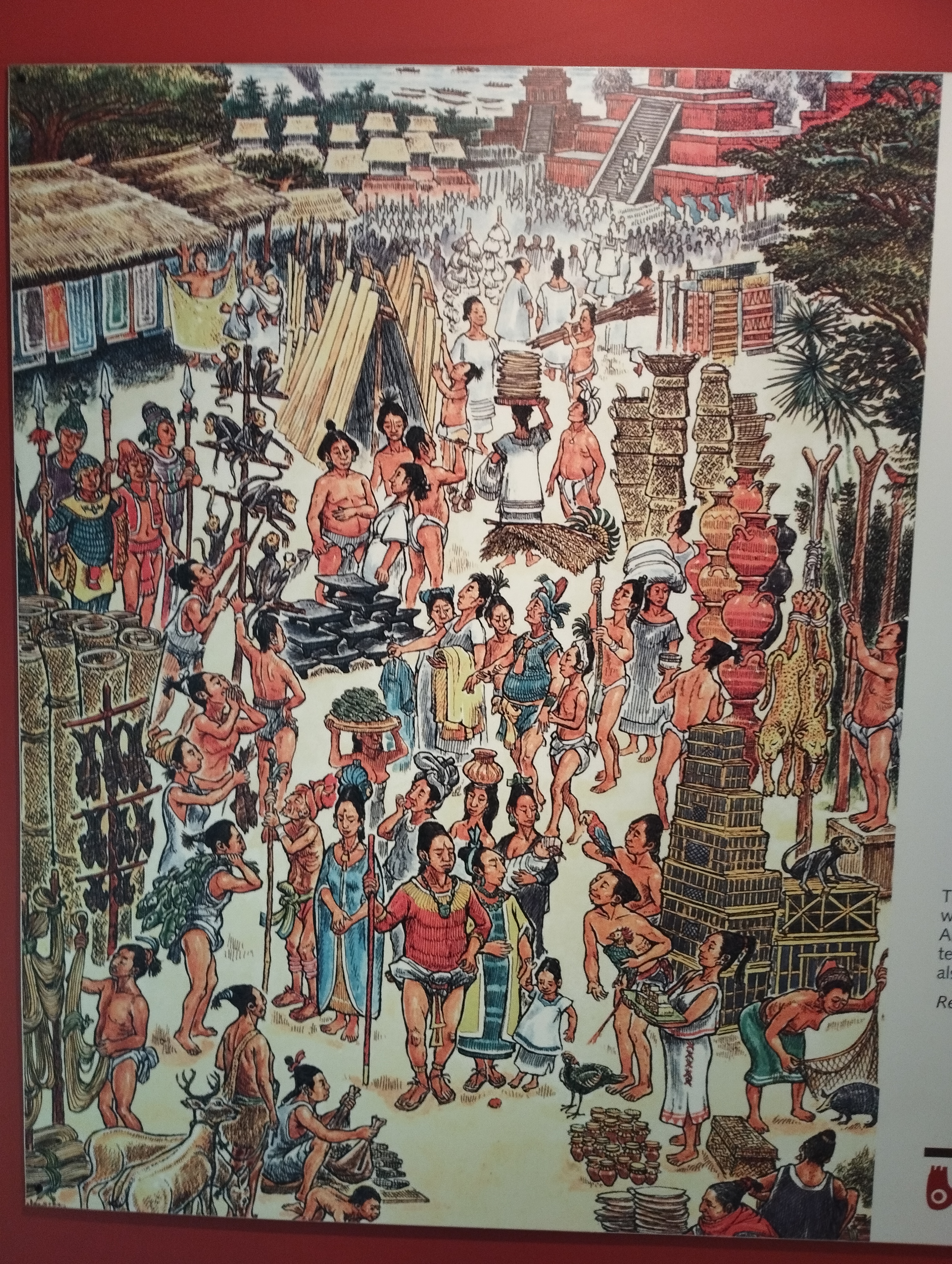
Lots of life in previous eras coalesced around the market, which was called the tianguis. Some of the markets in downtown San Salvador still seem like the chaos depicted below.

An art depiction of a market, complete with upside-down bird

How to kick off your Saturday morning

A relatively whistle-stop tour of El Salvador’s main anthropological museum has shown me different aspects of life here thousands of years ago. I’d like to return at some point to spend a bit less time directing kids to the toilet and more time allowing my mind to wander about living in the time of the Mayans and more. Not that I’d sacrifice my skin for it…

Amazing to think what has happened in our world since this was created

The modern colours, for Independence Day on Friday


Love you all,


Matt

Saturday, 16 September 2023

El Salvador - The Unknown National Park

September 10


Hello everyone!


A month back in El Salvador for round two in Central America’s smallest yet most densely populated country. Much of this has been spent working or at the dentist - the side of life not often seen in these blogs. The dental ordeal will come in the future. Why would you want to see that when you could see this?


This is in a national park called Walter Thilo Deininger. I know what you’re thinking: that doesn’t sound very…local. If you’re predicting that he’s German you would be…wrong! Though he studied in Hamburg, he was actually born in Guatemala, and spent most of his life as a businessman and philanthropist in El Salvador. In a classic example of not believing everything you read, a Wikipedia page says that Deininger settled in El Salvador in 1885…six years before he was born…

The park was set up in 1970, shortly after his death

Wikipedia: flawed, as I always tell my students!

Whatever he believed in, I’m sure Deininger probably didn’t expect to be remembered over fifty years after his death in the form of an adventure park near the beach. I’ll happily admit that I had never heard of this place, which doubles up as a national park, until a few days ago. The reason we were here was to take part in a run…which I assumed was a trail along the nearby beach.

The drive is about 30 kilometres

It wasn't a huge event, with numbers probably in the low hundreds

Partly this is my own naivety and ignorance - I didn’t bother finding out what the ‘WTD’ of the ‘WTD Challenge’ was, only knowing that the run was taking place near Surf City. This in itself is a strange concept, as there seems to me to be more than one place calling itself ‘Surf City’. However, I took the location to mean that we would be off-roading near a beach.

No surfing in this park, for sure!

The interesting colour of the race shirt

Technically true, I guess. The entrance to the national park is less than two kilometres away from the beach. But it is a very different world inside those gates. 

The park has two types of forest

Within the grounds you can find lots of different wildlife


I had collected kit for this run the day before in San Salvador. At this point we still didn’t know the route for either the 12 km or 6 km trails. With hindsight, I can see why they didn’t share them in advance. It wouldn’t have made much sense. After all, it’s hard to mark on the map the times when you’ll be vaulting over fallen tree trunks or scaling slippery rocks…


Logging has been an issue in the area, though
this probably fell due to natural causes!

This was a rise of over 150m in less than a kilometre

Being relatively close to our home in Santa Tecla, we didn’t have to overnight somewhere before the run. The flipside of this was a 4:30am wake-up, being on the road in the dark by 4:45am to drive a group of us down from almost 1000 metres above sea level to…well, pretty much sea level. Lovely sunrise, mind.

Candyfloss sunrise over the car park

The race was well-organised and started pretty much on time

Our run begins and starts serenely, a flat dirt path covered by wiry trees. The path soon seemed to transform into rocks on a river bed…which soon became a river.

This is a tributary of the Rio Amayo, which empties
into the sea a short distance from the park

The rocks were not the easiest to 'run' across

After skipping over another large trunk, I said to a friend something along the lines of, “I might regret saying this but I’m really enjoying this so far!” The regret came about 500 metres later when the route, marked by orange ribbons, started to head up the side of a steep hill.

The hill had a gradient between 15% and 20%

I had learnt my lesson from Ataco. There was no valiant attempt at running up this, particularly with the added kicker of it being slippery due to us being in the middle of rainy season. Breathing heavily, I got up to the top, was told to turn right…and then had to run up higher. At least this part was on a path.

Slightly easier but still uphill!

The uphill stretches kept coming until I reached a large boulder. At this point I was told to stop and have my photo taken with the El Salvador flag bizarrely perched nearby. It is Independence Month, I guess. The stunning view reminded me of how hot it can be nearer the coast so I got a move on, hopefully downhill.

The orange markers hanging from trees showed us where to go

Seems apt during Civic Month!


If I thought downhill was going to be easier, I was once again very naive. Rainy season and areas which don’t receive much light due to the trees = mud. This became particularly perilous when our 12km route joined back up with the 6km cohort, swelling the number of people trying to get down some rather steep and slippery slopes. At one point, to get around a group of walkers who were using poles, I took an alternative path and slid down on my rear end. It was probably the fastest I travelled down a slope in the entire run.


Some Salvadoreans are a bit...what's the
word...suicidal when taking on downhill sections

Plenty of weaving through trees in the second half

Strangely, not all of it was downhill. There were more slopes to ascend. With my legs being a bit heavier from previous inclines, I managed to trip over a tiny tree stump and fall into the dirt. Twice. On the same slope. 

View from near the highest point of the route

Being rainy season, it was lovely and green

Slightly muddy, I ran across the finish line and quickly jumped in the shower. Friends ended up on the podium for the 6 km races; I was very surprised to find I actually finished fourth in the 12 km version.

Apparently I'm 'smiles'

Originally I thought I was fifth - either way, miles away from the podium!

It wasn’t the run I was expecting. It wasn’t the place I was expecting. But Walter Thilo Deininger National Park was a surprisingly lovely place to spend a few hours on a Sunday morning, and somewhere I’m keen to return to in the future.


Love you all,


Matt